Hiking the Cranberry Wilderness: A Day Trip from Snowshoe

July 3, 2026 rafael 0 Comments 7 min read

Snowshoe Mountain makes a comfortable base for exploring more of Pocahontas County, and few side trips feel as wild as the Cranberry Wilderness. Covering 47,815 acres in the Monongahela National Forest, it is the largest Forest Service Wilderness Area in the eastern United States. More than miles of maintained trails pass through high-elevation forest, stream valleys, and remote Appalachian terrain.

For prepared visitors, cranberry wilderness hiking can become the most memorable day of a summer stay. This is not a paved overlook or a casual resort nature walk. Trails are unblazed, junction signs are limited, stream crossings do not have bridges, and potable water is unavailable.

The reward is solitude and a landscape managed to retain its wilderness character. The responsibility is to arrive with navigation skills, appropriate gear, realistic expectations, and a willingness to turn around when conditions demand it. Before planning the route, establish a comfortable home base. A Snowshoe vacation rental gives your group room to prepare breakfast, organize equipment, and return to an equipped kitchen and clean linens after the hike.

Why Visit the Cranberry Wilderness?

Across Pocahontas and Webster Counties, the Wilderness rises from about 2,400 to more than 4,600 feet. 1 Its forest and streams offer Snowshoe guests a remote, demanding counterpoint to resort activities. Cranberry wilderness hiking suits prepared hikers, not visitors seeking a short, heavily marked stroll.

Understand “Wilderness” Before You Go

The Cranberry Wilderness and the neighboring Cranberry Backcountry are related but not interchangeable. Federal Wilderness rules protect a more primitive environment. Bicycles and other forms of mechanical transport are prohibited inside the designated Wilderness, group size is limited to ten, and visitors are expected to minimize their impact.

Rules in adjacent areas may differ, so confirm the exact trail and land designation rather than assuming every “Cranberry” route follows the same policy. Trails are not blazed, and signs are generally limited to junctions. 1 A phone app is useful but should not be your only navigation tool. Carry an accessible paper topographic map and compass, and know how to use both.

The central rule of a wilderness day trip is simple: your group must be capable of getting itself back safely without depending on cell service, trail lighting, or immediate assistance.

Choosing a Route for a Day Trip

Two notable routes are the -mile Middle Fork Trail and 7.5-mile North Fork Trail. Listed length may not equal the full day-hike distance because access, connectors, and route format affect the total. Use this table only as a planning framework.

For a first cranberry wilderness hiking experience, a conservative out-and-back plan may be wiser than trying to complete an ambitious loop. It lets the group judge trail conditions, stream crossings, pace, and navigation before getting farther from the trailhead. Choose the route based on the least experienced member, not the strongest hiker. 

Check current Forest Service information for weather, storm damage, high water, fallen trees, and road access. Leave your route, trailhead, return time, and overdue-response plan with someone outside the group. 

Stream Crossings and Water Safety

There are no bridges at stream crossings in the Cranberry Wilderness, and water may be high. A crossing that looks easy in dry weather can become unsafe after rain. Never let a planned mileage goal pressure the group into crossing fast or deep water. If the current is stronger than expected, the footing is unclear, or anyone feels uncertain, turn around.

Potable water is not provided, and stream water must be treated. Carry drinking water plus a reserve; for longer days, bring a treatment method the group knows how to use.

Choose footwear for mud, uneven ground, and possible crossings. Carry dry socks in a waterproof bag. Trekking poles can improve balance, but they do not make an unsafe crossing safe.

Navigation, Timing, and Emergency Planning

Begin early enough to preserve daylight. Dense forest and mountain terrain can feel dark before the official sunset, and navigation becomes significantly harder after dusk. Set a turnaround time before leaving the trailhead and honor it even if the group has not reached a planned landmark.

Carry a paper map, compass, offline map, charged phone, and backup battery. Record the trailhead and each junction. If uncertain, stop rather than continuing in a guessed direction.

Carry a first-aid kit, warm and rain layers, a headlamp for every person, whistle, and extra food. A satellite communicator can add protection, but it does not replace sound judgment.

Review the local weather information before leaving your rental, then compare it with an official forecast for the trail area. Conditions at Snowshoe do not guarantee identical conditions along your route.

What to Pack

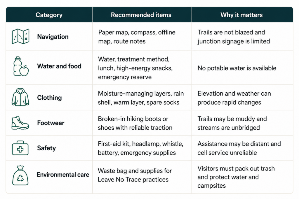
The right equipment depends on season, route, experience, and weather. The following checklist covers the basic categories for a summer day trip:

Wilderness Rules and Leave No Trace

Visitors are responsible for protecting the place that makes cranberry wilderness hiking special. The Forest Service prohibits groups larger than ten and mechanical transport, including bicycles, inside the Wilderness. Pets must remain under control. For any overnight use, camps should be located at least 200 feet from roads, streams, and trails. Day hikers should apply the same principle by avoiding damage to streambanks and undisturbed areas.

Pack out every item you bring. Do not create shortcuts across switchbacks, disturb wildlife, carve trees, build unnecessary fire rings, or leave food scraps. Even biodegradable waste such as fruit peels is foreign to the environment and should return with you.

A dog must be fit for the route, controllable around wildlife and hikers, and prepared for rough terrain. Reserve a designated pet-friendly Snowshoe rental rather than assuming every home accepts animals.

A Practical Day-Trip Schedule

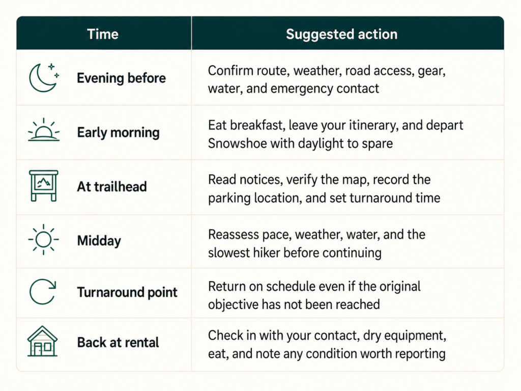
A simple schedule reduces rushed decisions:

Leave extra time for the drive back. After cranberry wilderness hiking, fatigue can make winding roads more demanding; dry clothing, water, and a snack in the vehicle will help.

Return to a Comfortable Snowshoe Home Base

A wilderness outing feels even better when a comfortable place is waiting afterward. Casago Snowshoe properties include equipped kitchens, linens, towels, and parking, while property-specific features vary. Read the listing to confirm the exact layout and amenities that matter to your group.

Larger groups can compare Snowshoe rental homes. If you want advice on matching a property to your summer plans, contact the local Casago Snowshoe team before booking.

Frequently Asked Questions

  • How large is the Cranberry Wilderness?

The designated Wilderness covers 47,815 acres in Pocahontas and Webster Counties and is the largest Forest Service Wilderness Area in the eastern United States. 

  • How many miles of trails are available?

The Forest Service lists more than 70 miles of maintained hiking trails. Route length, difficulty, access, and current conditions vary. 

  • Are Cranberry Wilderness trails marked? 

They are not blazed, and signs are generally limited to junctions. Carry a paper map and compass and know how to use them.

  • Are there bridges across streams?

No. Stream crossings are unbridged, and water can be high. Never cross when depth, current, or footing feels unsafe. 

  • Can I drink water from a stream?

Not without treatment. Potable water is unavailable, and any natural water should be filtered, boiled, or otherwise properly treated.

  • Are bicycles allowed?

Bicycles and other mechanical transport are prohibited inside the designated Wilderness. Rules in the adjacent Backcountry may differ, so verify your location.

  • Can I bring my dog?

Pets are permitted but must remain under control. Choose a route suitable for the dog and reserve lodging that is specifically pet friendly.

  • Is this a good hike for beginners?

The unblazed trails, crossings, and navigation requirements favor prepared hikers. Beginners should go with an experienced leader and choose a conservative route.

Plan the Adventure, Respect the Wilderness

The best cranberry wilderness hiking day is not necessarily the one with the most miles. It is the one in which everyone returns safely, the landscape shows no sign of the group’s visit, and the experience builds respect for West Virginia’s protected mountain country.

Choose a realistic route, check official conditions, pack for self-reliance, and reserve a Snowshoe base that makes preparation and recovery easy. Browse vacation rentals and start planning a summer stay with room for one truly wild day.

Leave a Comment

Your email address will not be published. Required fields are marked *